Flood intensity
The intensity of floods may be described in terms of height , class , depth , flow rate and speed.
Height
The height of a flood is often described in terms relative to a fixed marker, such as a post, which is often placed in an arbitrary position near the river. Thus, a river height of 4 metres at a given place will often not mean that the river is in flood, but that this is a fairly normal height, whereas the same height at a different point on the river may mean that the river is in flood.
Class
To alleviate the problem of using height as a flood measure, floods are often described in terms of minor , moderate and major classes . The tree classes are:
|
|
|
|
|
|
|
|

Often in flood warnings, both the heights and the flood classes are given for different points on a river, as the local people who receive the warnings may use the prior experience of either description to decide how to act.
Depth
Another way of describing the intensity of floods is by linking flood heights to the floor levels of buildings that may be affected. This gives an idea of depth and is very useful for evacuation planning and land use planning.
Table 5.1 shows the depth of water relative to building floors for a flood of 4.25 metres height at the river gauge. This means that the top of the flood water is a given height above the floor of each building, e.g. the top of the water is 2.1 metres above the floor of the pavilion in Ferry Street during a flood of 4.25 metres at the gauge.
New Norfolk flood depth tables
Derwent River, Tasmania
Predicted gauge height at New Norfolk is 4.25 metres
Assumed flood slope is 1 in 1724
Estimated number of properties inundated at this height is 20
No |
Street |
Type |
Construction |
Remarks |
Prop |
Storeys |
Depth |
|
Ferry |
Util |
CC/C.BLK.I |
Toilet Block |
1963 |
1 |
2.2 |
|
Ferry |
Rec |
CC/C.BLK.I |
Pavilion |
1953 |
1 |
2.1 |
|
Ferry |
Rec |
CC/C.BLK.I |
Bowls Club |
1953 |
2 |
2.0 |
|
Ferry |
Rec |
CC/BK/I |
Pigeon Club |
1953 |
1 |
1.9 |
|
|
Rec |
CC/C.BLK.I |
Pavilion |
1972 |
1 |
1.8 |
|
|
Rec |
CC/C.BLK.I |
Regatt/Pav |
|
1 |
1.7 |
|
Alfred |
Res |
CC/W.B/I |
Caretaker |
1940 |
2 |
1.7 |
|
Alfred |
Rec |
CC/BK.I |
Toilet |
1938 |
1 |
1.7 |
|
Alfred |
Rec |
CC/I/I |
Shed |
1938 |
1 |
1.2 |
|
Alfred |
Rec |
ST/AL/I |
Demountable |
1938 |
1 |
0.9 |
|
Alfred |
Rec |
ST/AL/I |
Demountable |
1938 |
1 |
0.9 |
107 |
Boyer |
Res |
CC/BK.I |
|
2098 |
1 |
0.8 |
105/1 |
Boyer |
Res |
CC/BK/I |
|
2099 |
1 |
0.7 |
|
Alfred |
Rec |
ST/AL/I |
Demountable |
1938 |
1 |
0.6 |
105/2 |
Boyer |
Res |
CC/W.B/I |
|
2099 |
1 |
0.6 |
|
Boyer |
Res |
CC/BK/I |
Williams (Own) |
2097 |
1 |
0.6 |
|
Alfred |
Rec |
ST/AL/I |
Demountable |
1938 |
1 |
0.5 |
103 |
Boyer |
Res |
CC/BK/T |
|
2099 |
1 |
0.3 |
10 |
Ferry |
Res |
CC/BK/I |
|
1954 |
1 |
0.2 |
44 |
Rocks |
Rec |
CC/C.BLK/I |
Rowing Club |
967 |
1 |
0.1 |
New Norfolk flood depth tables-Legend
NO |
House or property number, if applicable |
STREET |
Street or location |
TYPE |
RES-Residential, COM-Commercial, UTIL-Utility, |
CONSTRUCTION |
BK-Brick, AL-Aluminium, B.CLAD-Brick Cladding, I-Iron Roof, HP- Hardiplank, SH-Shingles, ST-Stumps, C.BLK-Concrete Block, STN-Stone, W.B-Weatherboard, CC-Concrete. |
REMARKS |
Comment on structure use |
PROP |
Identification number as shown on 1:5000 orthophotic maps |
STOREYS |
Number of storeys in structure |
DEPTH |
Estimated depth over floor in metres |
Source: Bureau of Meteorology (1993). New Norfolk Flood Depth Tables , Bureau of Meteorology: Hobart , April 1993, p. 13.
Flow rate
Yet another way of describing flood intensity is the flow rate . This is a description of the volume of water flowing past a particular point in a given time period, and the units are either cusecs (cubic feet per second) or cumecs (cubic metres per second). A cusec is equal to 0.028 cumecs. This method of description is often used in relation to dam safety, as a very high flow rate over a dam with insufficient spillway capacity may lead to dam failure.
Speed
A final way of describing the intensity of a flood is the speed or velocity of the water at a given point. This is a useful measure as speed, coupled with water depth, will indicate the scale of damage of which the moving water is capable. Figure 5.1 shows the speed and depth of flowing water that can cause failure to various building types.
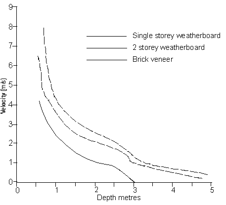
Figure 5.1
Critical flood velocity and depth for building failure (based on Black, 1975)
Source: Smith, D.I. (1992). Damage estimation and preparedness for dam failure flooding, Ancold Bulletin, no. 90, p. 26.
Of course, in floods that occur in flat, inland areas where the water moves very slowly, there is less likelihood of flowing water causing structural damage.
The other use of describing the velocity of floodwater is determining when and where floodboats can be used for rescue-boats will simply not make headway against water that is moving near or above the normal speed of the boat.