Principle of hazard and risk analysis documentation
Try to express the results of your analysis in terms that are of greatest value to emergency management, and endeavour to keep those terms concrete and understandable.
So be careful in choosing the most appropriate units of measurement in your hazard analysis.
It is possible to show more information about the effects of earthquakes, using data of the geology of a given area-this is an example of microzonation -i.e. the identification of hazard/risk zones at the micro (large-scale) level, such as town, city. The method is to accept the very general data on earthquake intensity and probability that has been used to develop the small scale maps, and overlay this data on a detailed study of local geology. As different soil types react differently to earthquakes (for example sedimentary soils may 'liquefy', causing buildings to sink) it is possible to predict more accurately the scale of damage likely at particular points.
Geoscience Australia provide a range of earthquake hazard maps on their online database available to search and browse through at:http://webmap.ga.gov.au/imf-natural_hazards/imf.jsp?site=natural_hazards_earthquake
It is well worth taking a few minutes to look through their database and gain an appreciation of the value that hazard information displayed in a map format can give.
A number of hazard maps relating to earthquake and geological hazards are provided in figures 5.4 - 5.7 below as a means of demonstrating how maps can portray information relevant to hazards.
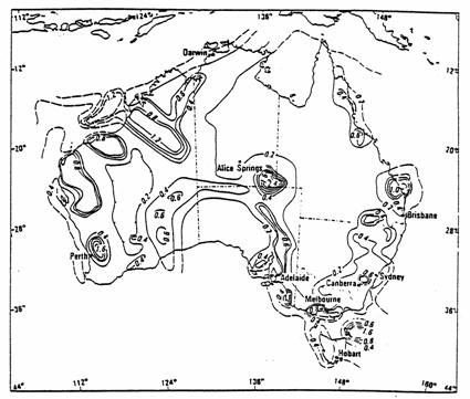
Figure 5.4
Australia 's peak ground acceleration (m/s 2 ) with a 10% chance of being exceeded in a 50 year period
Source: Gaull, B.A. et al , 1990, 'Probabilistic earthquake risk maps of Australia ', Australian Journal of Earth Sciences , vol. 37, p. 181.
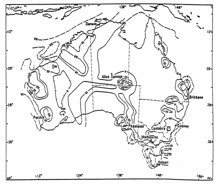
Figure 5.5
Australia 's peak ground intensity (MM) with a 10% chance of being exceeded in a 50 year period
Source: ibid., p. 182.
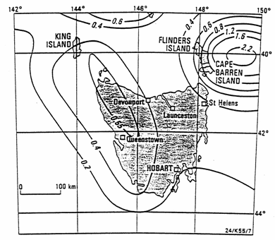
Figure 5.6
Tasmania : Peak ground acceleration (m.s - 2 ) with a 10% probability of being exceeded in a 50 year period. Note the variable contour interval
Source: Michael-Leiba, M.O. and Gaull, B.A. (1989). 'Probabilistic earthquake risk maps of Tasmania ', Journal of Australian Geology and Geophysics, vol. 11, p. 86.
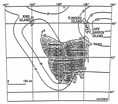
Figure 5.7
Tasmania :
Peak ground intensity (MM) with a 10% probability of being exceeded in a 50 year period
Source: loc. cit.
Sampling
Sampling refers to two things:
- the number of areas from which data has been collected;
- the period of time over which the data was collected for a given area.
The accuracy of our hazard maps is obviously dependent upon the extent of the sampling (both in terms of area and time span) on which they are based. The earthquake maps for Australia and Tasmania illustrate both of these sampling limitations.
Accurate and scientific earthquake data, particularly for the low intensity earthquakes for most areas of Australia , has only been gathered during the latter half of this century, although it is possible to infer sources and intensities of historical earthquakes from newspaper and other reports. Given that earthquakes of a damaging intensity are relatively infrequent events, we need to treat the analysis of past events and probability predictions of future events with an appropriate degree of scepticism. In other words, areas that are shown on these maps to have a low probability of earthquake may in fact have a medium to high probability.
It is also interesting to note from these maps that many of the high probability earthquake zones are clustered around capital cities. This may be, in part, due to a larger number of potential observers of earthquakes (who report on the intensities of earthquakes) and a greater concentration of seismographs.
Sampling also influences considerations of map scale and detail. You will notice that the information shown on the earthquake map for Tasmania is not much more detailed than that shown for Tasmania on the smaller scale map of Australia . This is because the information sampled does not allow greater detail at a larger scale.
So, factors of scale, chosen units of measurement and sampling procedures influence the value and use of hazard maps. However, given that we take these factors into account, hazard mapping is a powerful tool in helping to describe the nature of hazards.